
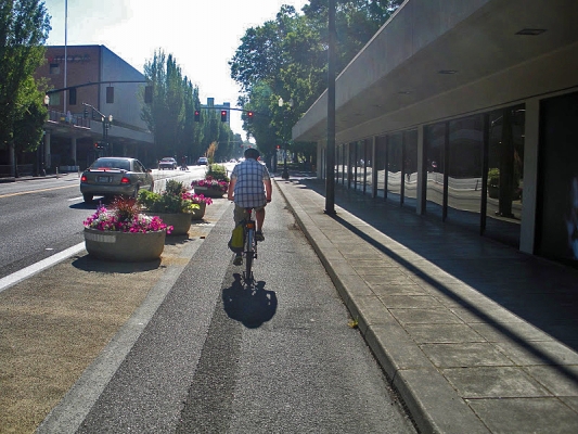
Summary: The most recent edition of the Highway Capacity Manual (HCM) contains analysis procedures for measuring the level-of-service (LOS), also referred to as quality of service, provided by an urban roadway to bicyclists. The method uses different design and operating features of the roadway segment (e.g. width, motor vehicle volumes and speeds) to assess an LOS grade of A (best) to F (worst). These procedures are used by planners and engineers to recommend how existing streets could be retrofitted or new streets designed to better serve people on bicycles (and other modes). However, the current HCM does not include methods that address protected bike lanes (aka “cycle tracks” or “separated bike lanes”), only conventional striped bike lanes, shoulders, and shared streets. There are other methods for predicting comfort from a bicyclist’s perspective that do consider protected bike lanes, but they are either based only on expert opinion or on surveys in Denmark.
This presentation will describe how to evaluate the level-of-service of a protected bike lane using results from surveys conducted in the United States. The model developed by this project could be used to supplement the current HCM to objectively consider a wider...
Read moreThe video begins at 1:32.
Topic: Four Types of Cyclists: What do we know and how can it help?
Labeling or categorizing cyclists has been occurring for over a century for a variety of purposes. Dr. Dill's research aimed to examine a typology developed by the City of Portland that includes four categories: Strong and the Fearless, Enthused and Confident, Interested but Concerned, and No Way No How. Unlike several other typologies, this widely referenced typology is intended to apply to all adults, regardless of their current cycling behavior. This seminar will present her findings, focusing on differences between the four types and a better understanding the market for increasing cycling for transportation.
View slides
If you would like to receive continuing education credits such as PDH or CM, please make sure to complete this evaluation form once you've watched the entire video so that we have a record of your attendance.
Watch video:
Read more
PRESENTATION ARCHIVE
OVERVIEW
The National Street Improvements Study, conducted by PSU in conjunction with PeopleForBikes and consulting firm Bennett Midland, researched the economic effects of bicycle infrastructure on 14 corridors across six cities — Portland, Seattle, San Francisco, Memphis, Minneapolis and Indianapolis. The study found that improvements such as bicycle and pedestrian infrastructure had either positive or non-significant impacts on the local economy as measured through sales and employment. In this webinar, lead researcher Jenny Liu will share the results of the investigation and the unique methodology for investigating these economic outcomes.
THE RESEARCH
This webinar is based on a study funded by the National Institute for Transportation and Communities (NITC) and the Summit Foundation, and conducted at Portland State University. Read more about the research: ...
Read more
View slides
Watch video:
For a number of reasons—congestion, public health, greenhouse gas emissions, energy use, demographic shifts, and community livability to name a few—the importance of walking and bicycling as transportation options will only continue to increase. Currently, policy interest and infrastructure funding for nonmotorized modes far outstrip our ability to successfully model bike and walk travel. In the past five years, we have learned a lot about where people prefer to bike and walk, but what can that tell us about whether people will bike or walk in the...
Read more