PRESENTATION ARCHIVE

Miss the webinar or want a look back?

OVERVIEW

The "Fast Track" project at the University of Oregon focuses on a mode of transportation that is sometimes left out of vehicle-to-infrastructure, or V2I, conversations: Bicycling. NITC researchers developed an app based on a new technology being integrated into modern cars: GLOSA, or Green Light Optimized Speed Advisory. GLOSA allows motorists to set their speed along corridors to maximize their chances of catching a "green wave" so they won't have to stop at red lights.

This project demonstrates how GLOSA can be used by bicyclists in the same way it is used by motorists, with a test site on a busy car and bike corridor feeding the University of Oregon campus: 13th Avenue in Eugene, Oregon. Researchers developed a smartphone app that tells a cyclist whether they should adjust their speed to stay in tune with the signals and catch the next green. The project demonstrates how university researchers, city traffic engineers, and signal-controller manufacturers can come together to help bicyclists be active participants in a smart transportation...

Read more

By Jennifer Dill, Ph.D.
Professor, Urban Studies & Planning 
Director, TREC

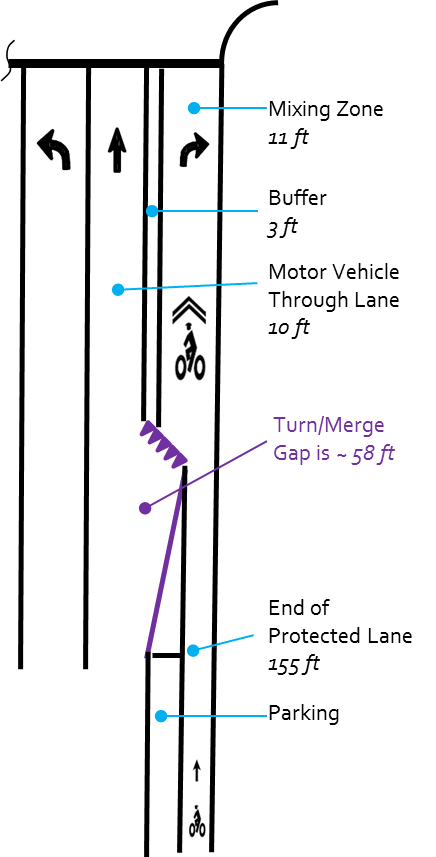
This week I’m at the International Travel Survey Conference in Australia. The conference happens every three years, attracting over 100 geeky people who spend time thinking about things like stated preference experiments, smartphone data collection, combining sampling frames, and respondent burden. I presented some work from our five city Green Lanes project, comparing our survey data with “objective” measures, such as videos and traffic counts. The focus was on intersections, where the protected lane is no longer separated from motor vehicles. An example of one design used in Portland, OR is shown in the adjacent figure.


Some of the...

Read more

View slides

Abstract: Existing regional travel forecasting systems are not typically set up to forecast usage of bicycle infrastructure and are insensitive to bicyclists' route preferences in general. We collected revealed preference, GPS data on 162 bicyclists over the course of several days and coded the resulting trips to a highly detailed bicycle network model. We then use these data to estimate bicyclist route choice models. As part of this research, we developed a sophisticated choice set generation algorithm based on multiple permutations of labeled path attributes, which seems to out-perform comparable implementations of other route choice set generation algorithms. The model was formulated as a Path-Size Logit model to account for overlapping route alternatives. The estimation results show compelling intuitive elasticities for route choice attributes, including the effects of distance and delay; avoiding high-volumes of vehicular traffic, stops and turns, and elevation gain; and preferences for certain bike infrastructure types, particularly at bridge crossings and off-street paths. Estimation results also support segmentation by commute versus non-commute trip types, but are less clear when it comes to gender. The final model will be implemented as part of the regional travel forecasting system for Portland, Oregon, U.S.A.

Watch video

Slides are not available for this presentation.

During the March 2011 earthquake/ tsunami/nuclear disaster, the internet filled with stories of how something quite ordinary in Japanese life became an important lifeline—the bicycle. For example an 83-year-old woman escaped the tsunami by bicycle, and due to public-transport disruptions, bicycle stores sold out of bicycles as quickly as supermarkets sold out of food. However not just in disasters, but in daily life, the most reliable, sustainable form of transportation, next to walking, is via Japan’s estimated 80,000,000 bicycles, affectionately called mamachari.

This illustrated presentation, based on four-years of cultural-landscape research culminating the publication of世界が称賛した日本の町の秘密 (Secrets of Japanese Cities the World Admires. Tokyo: Yousensha, 2011), begins by discussing why mamachari are perfect for local transportation and the many practical ways Japanese use them. It then explores why many of Japan’s densely populated, fine-grained neighborhoods with auto-resistant narrow streets and nearby shopping, make ideal bicycle neighborhoods. Issues explored will include the mamachari’s impact on: neighborhood livability; sustainability; public health through active transportation; fostering direct human contact not possible with motor-car travel; and maintaining the compact human scale of communities by...

Read more

Portland State students redesign busy Portland street for active transportation

Webinar: Bike Ped Portal, the National Bicycle and Pedestrian Count Archive

View the presentation slides here.

This project builds on the success of NITC’s first Pooled Fund project that created the first national...

Read more

The video begins at 1:47.

Joseph Broach, PhD candidate in Urban Studies, will discuss the results of his research, which models the propensity of children aged 6-16 to walk or bike to parks and school without an adult chaperone, extending existing work on children’s active travel in several ways: 1) focus on travel without an adult, 2) inclusion of school and a non-school destinations, 3) separate walk and bike models, 4) consideration of both parent and child attitudes and perceived social norms, 5) explicit inclusion of household rules limiting walking or bicycling.

Pages